top of page


BATHYMETRIC SURVEYING
USING MBES
Uses Multibeam Echosounder; Ideal for Deep water bathymetric survey (Hydrographic Survey)
Our Bathymetric surveying output produces unprecedented clean data, providing faster operational surveys and reduced processing time.
Multibeam Echosounder LiDAR Surveying, also known as Hydrographic Surveying, is a powerful underwater mapping method that uses sound waves to create detailed 3D images of the seafloor. Unlike traditional single-beam sonar that sends one pulse at a time, multibeam systems emit a fan-shaped array of sound pulses, allowing for much wider and denser coverage with each pass.
From a vessel equipped with a multibeam echosounder, sound pulses are emitted and bounce back from the seabed. These returns are then processed to create accurate bathymetric maps showing depth, contours, and underwater features. The denser the coverage, the better the quality of the data—which is especially useful in complex environments like ports, reefs, and offshore wind sites.

Faster Fieldwork

Higher Accuracy

Richer Details

Smarter in Cost
OUR BATHYMETRIC SERVICES


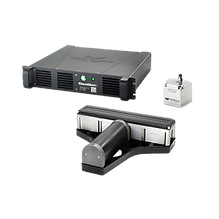
SEABAT T50-R
WHAT'S MAKING AERIAL BATHYMETRIC LIDAR POSSIBLE?
AB Surveying and Development uses the SeaBat T50-R for bathymetric surveying, producing exceptionally clean data for faster operations and reduced processing times. Its full frequency agility from 190 to 420 kHz ensures high performance and efficiency even in challenging acoustic conditions, delivering reliable and accurate depth measurements for coastal and hydrographic applications.


bottom of page