ALL SERVICES
CORE SERVICES
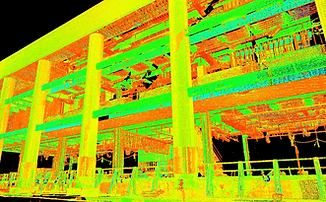
.jpg)
Aerial Topographic LIDAR Surveying
Ideal for shallow, clear waters, coral reef areas, coastal mapping, and port surveys.

Mobile LIDAR Surveying
Ideal for corridor projects like highways, railways, and pipelines.

Terrestrial LIDAR Surveying
Ideal for architectural and cultural heritage documentation, as-built models, and structural monitoring.

Aerial Bathymetric LIDAR Surveying
Ideal for shallow, clear waters, coral reef areas, coastal mapping, and port surveys.

OTHER SERVICES

Global Mapper
Official partner of ABSD in terms of geospatial data processing
Partnerships, Software
Price

Wind LiDAR (WRA)
Best for: Offshore and onshore wind energy development.
Offshore, Partnerships
Price

Geophysical Analysis
Best for: Infrastructure planning, foundation design, and environmental studies.
Offshore, Partnerships
Price

Side Scan Sonar
Best for: Seafloor imaging, search and recovery (SAR), and coastal security surveys.
Offshore
Price

Marine Magnetometery
Best for: Wreck detection, locating pipelines, unexploded ordnance (UXO), and buried ferrous objects.
Offshore
Price

Subbottom Profiling
Best for: Marine geology, offshore construction, and geotechnical studies.
Offshore
Price

Sound Velocity Profiling
Best for: All sonar-based surveys in both saltwater and freshwater.
Offshore
Price

Single beam Echosounder
Best for: Preliminary surveys, rivers, and small-scale or budget-limited projects.
Offshore
Price

Flow Measurement
Best for: Analyzes drainage or sewage system flow for facility sizing and infrastructure planning.
Onshore
Price

Cadastral Survey
Best for: Defines legal property boundaries for ownership, land titling, and dispute resolution.
Onshore
Price

Control Survey
Best for: Establishes reference points for all other surveys, ensuring consistency across large areas.
Onshore
Price

Mining Survey
Best for: Supports exploration, feasibility studies, and site monitoring in mining and energy projects.
Onshore
Price

Levelling Survey
Best for: Provides accurate elevation differences between points; critical for drainage, roads, and slope design.
Onshore
Price

Subdivision Survey
Best for: Divides land into smaller lots for residential, commercial, or inheritance purposes.
Onshore
Price

Flood mapping
Best for: Identifies flood-prone areas to strengthen disaster preparedness and community resilience.
Onshore
Price

Bridge Survey
Best for: Supports bridge design, construction, and quality assurance through precise terrain and layout data.
Onshore
Price
Structural Survey
Best for: Evaluates building condition and stability; highlights repair and maintenance needs.
Onshore
Price

Detailed Engineering Survey
Best for: Essential for plants, tunnels, pipelines, and major infrastructure needing exact measurements.
Onshore
Price

As-Built and Detailed As-Built Survey
Best for: Documents completed structures for compliance, payment, and record-keeping.
Onshore
Price

3D As-built Survey
Best for: Perfect for industrial facilities, bridges, and large structures where accurate 3D records are needed.
Onshore
Price

Relocation Survey
Best for: Re-establishes missing or disputed property boundaries with precision.
Onshore
Price

Cross Section Survey
Best for: Provides terrain profiles for road, rail, and canal construction projects.
Onshore
Price

Parcellary Survey
Best for: Used for right-of-way acquisition and identifying affected lots in infrastructure projects.
Onshore
Price

Tower Spotting
Best for: Ensures accurate placement and height of towers for stability, ground clearance, and efficient transmission.
Onshore
Price

CAAP Height Clearance
Best for: Required for transmission or tall structures near flight paths to comply with aviation safety regulations.
Onshore
Price

Transmission Line Route Survey
Best for: Ideal for planning safe and efficient routes for power lines, considering terrain, environment, and engineering constraints.
Onshore
Price