Are We Really Saving Money by Not Updating Our Maps? What LGUs Are Missing
- Clinton Bravo
- Feb 5
- 4 min read

Most LGUs don’t choose to plan with outdated maps. This usually happens because the old topo/as-builts are already “there,” the basemap is “free,” and updating feels like an extra cost. But in real-world planning, the most expensive part isn’t mapping, it’s what happens when projects move forward on assumptions.

When the base map is old, planning can look fine in presentations, but the moment you start implementing drainage upgrades, road works, flood mitigation, zoning enforcement, or even tax mapping the site forces corrections. That’s when the “savings” disappear and you start paying through redesigns, delays, disputes, and missed collection opportunities.
The real cost of not updating maps is not obvious, until it is.
Outdated basemaps usually fail quietly. The errors aren’t always dramatic; they’re small gaps that compound:
Roads get widened and the right-of-way reality changes.
Drainage paths shift, get clogged, or get blocked by new structures.
Communities expand and the built environment changes faster than records.
Low-lying areas and flow paths get misunderstood because the elevation baseline is no longer accurate.
By the time teams discover the mismatch, the project is already in motion so fixes are more expensive, approvals take longer, and implementation becomes reactive.
Why LGUs should survey/update their city on a 3–5 year cycle
In fast-changing areas, a base map has a “useful life.” Once roads are widened, drainage patterns are altered, new structures appear, and informal growth fills in gaps, the map may still look usable but it becomes less reliable for decisions. That’s why many national mapping and geospatial agencies don’t treat basemaps as a one-time asset; they treat them as a dataset that must be refreshed on a cycle, commonly around 3–5 years, with more frequent updates in highly dynamic areas.

In LGU terms, the “5-year logic” is practical:
First, it matches political and planning cycles. LGUs typically align major programs, DRRM investments, and infrastructure priorities with midterm plans and annual investment plans. If your basemap is older than the plan it’s guiding, you’re planning with yesterday’s reality.
Second, it reduces repeat spending on the same problem. When the baseline is outdated, you don’t just spend on the project, you also spend on revisions, validation, rework, and change orders. A refreshed baseline cuts those downstream costs because you’re not discovering critical constraints late.
Third, it supports multiple offices using the same “truth layer.” The Engineering Office, Assessor’s Office, CDRRMO, Planning Office, and Treasury all benefit when they’re working from a common, survey-grade baseline instead of conflicting files and partial references.
Fourth, it keeps flood mapping credible. Flood behavior is extremely sensitive to terrain, drainage paths, obstructions, and built-up expansion. If the base elevation and surface conditions are outdated, the model can point resources to the wrong places or miss micro-risk areas that matter on the ground.
What ABSD projects show LGUs can do when the baseline is “decision-ready”
Baguio City: Citywide mapping built for flood, tax, and planning use
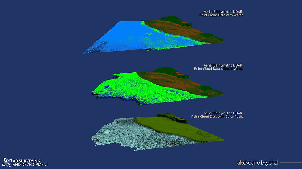
A strong example is AB Surveying & Development’s citywide LiDAR mapping work with Baguio City. ABSD’s project write-up explicitly connects the initiative to LGU priorities infrastructure planning, road network management, flood mapping, tax mapping, and disaster risk management because the goal wasn’t “a map,” but a baseline the city could use for governance and planning.
The same case also highlights an important point for LGUs: speed can be achieved without sacrificing usability, especially when the approach matches the terrain constraints. ABSD notes the aerial LiDAR survey was conducted via helicopter and completed through a flight scan lasting only eight (8) hours, which underscores how quickly a city can get a refreshed, survey-grade baseline compared to conventional approaches.
Naga City: Flood-ready planning starts when the city can “see” drainage and terrain behavior
ABSD’s initiative with Naga City is another clear example of why “updated maps” are not just a planning accessory. ABSD describes donating LiDAR-based topographic data covering 3,000 hectares and frames the dataset as something that supports better governance and disaster preparedness not just visualization.
In practical terms, the value is that LGUs can work from a baseline that makes it easier to identify low-lying areas, drainage flow paths, and the real urban layout, so flood planning and infrastructure prioritization are based on measurable conditions rather than outdated references.
Santa Rosa, Laguna: Proof that LGU-scale speed is possible
Our recent turnover in Santa Rosa, Laguna is a timely example of what many LGUs assume is impossible: getting broad coverage fast enough to be useful. ABSD surveyed about 5,700 hectares in 36 days, which is required and aligned to LGU priority uses like flood mapping, tax mapping, and planning implementation.
If there’s one takeaway from all of this, it’s that LGUs rarely lose money because they “didn’t have a map.” They lose money because they moved forward with a map that no longer reflects their city. When basemaps are outdated, planning becomes assumption-driven, and the costs show up later through revisions, delays, disputes, missed collections, and flood-control projects that don’t perform as expected.
Baguio shows that a citywide refresh can be done efficiently and still produce survey-grade outputs that support flood mapping, tax mapping, and planning decisions. Naga shows how updated terrain data strengthens flood readiness by helping LGUs “see” drainage behavior and prioritize interventions more defensibly. Sta. Rosa shows that fast, LGU-scale coverage is possible while still maintaining high standards of quality and reliability.
If your LGU is planning for flood risk reduction, drainage upgrades, road works, zoning enforcement, or tax mapping, the fastest win is often the same: refresh your baseline first.
To get started, you can:
Request a quick quotation: https://www.absurveyingph.net/get-a-quick-quotation
Or email us at info@absurveyingph.net to schedule a short scoping call. We’ll help you identify priority zones, outline the right outputs for your offices (Engineering, Assessor, CDRRMO, Planning), and recommend a survey package that fits your timeline and budget.


Comments