![[ABSD] White Logo.png](https://static.wixstatic.com/media/c6ec9d_74fae8190bdc4b4bbae4d07cc36b8aff~mv2.png/v1/fill/w_193,h_48,al_c,q_85,usm_0.66_1.00_0.01,enc_avif,quality_auto/%5BABSD%5D%20White%20Logo.png)
Understanding Hydrographic and Bathymetric Surveys: Mapping What Lies Beneath the Water

When people think of surveying, they often picture engineers measuring land, establishing property boundaries, or creating topographic maps. However, many of today's infrastructure and development projects extend beyond dry land and into rivers, lakes, reservoirs, ports, and coastal waters.
Before engineers can design a bridge foundation, dredge a navigation channel, construct a port, or rehabilitate a river, they first need to understand what lies beneath the water's surface.
This is where hydrographic and bathymetric surveys become essential.
Although these terms are often used interchangeably, they are not exactly the same. Understanding the difference between them can help project owners, engineers, developers, and government agencies identify the right survey for their project and make more informed decisions.
What Is a Hydrographic Survey?
Hydrography is the science of measuring and describing the physical features of oceans, seas, lakes, rivers, and other bodies of water.
A hydrographic survey is therefore much more than simply measuring water depth. It aims to understand the underwater environment by collecting information that supports navigation, engineering, environmental management, marine construction, and infrastructure development.
Depending on the project's objectives, a hydrographic survey may include:
Water depth (bathymetry)
Underwater terrain
Shoreline features
Tides and water levels
Navigation hazards
Underwater structures
Seabed characteristics
Subsurface conditions
In many engineering projects, hydrographic surveys provide the baseline information needed before design and construction can begin. For example, before expanding a port or constructing a bridge, engineers need to understand not only how deep the water is, but also the shape of the seabed, existing underwater obstructions, sediment conditions, and other environmental factors that may influence the project.
What Is a Bathymetric Survey?
If hydrographic surveying is the broader discipline, bathymetric surveying is one of its most important components.
A bathymetric survey focuses specifically on measuring the depth and shape of the underwater terrain. Think of it as the underwater equivalent of a topographic survey. Just as a topographic survey maps hills, valleys, slopes, and terrain elevations on land, a bathymetric survey maps those same features beneath the water's surface. The final output is often a Digital Terrain Model (DTM), contour map, or three-dimensional representation of the seabed that engineers can use for planning and analysis.
Bathymetric surveys are commonly performed for:
Ports and harbors
Rivers
Lakes
Reservoirs
Dams
Coastal engineering projects
Dredging operations
Flood studies
Environmental monitoring
Without accurate bathymetric information, engineers would be making critical decisions without fully understanding the terrain hidden beneath the water.
So, What's the Difference?
One of the easiest ways to understand the relationship is to think of bathymetry as a subset of hydrography.
A bathymetric survey answers a specific question: "What does the underwater terrain look like?"
A hydrographic survey answers a broader question: "What conditions exist beneath and around the water that could affect navigation, engineering, construction, or environmental management?"
In many projects, bathymetric data forms one of the key deliverables of a hydrographic survey.
The two are therefore closely related, and in practice, many projects require both.
How Are These Surveys Performed?
Several technologies are available for hydrographic and bathymetric surveys, with the choice depending on water depth, required accuracy, environmental conditions, and project objectives.
Single Beam Echo Sounder (SBES)
A Single Beam Echo Sounder measures water depth directly beneath the survey vessel using acoustic pulses. Each pulse produces a single depth measurement, similar to how conventional topographic surveys collect individual ground points.
Because measurements are collected along survey lines, multiple passes are required to build a complete model of the underwater terrain. Single beam systems remain a reliable and cost-effective solution for many river, lake, reservoir, and preliminary hydrographic surveys.
Multibeam Echo Sounder (MBES)
Unlike single beam systems, a Multibeam Echo Sounder emits hundreds of acoustic beams simultaneously. Instead of measuring only one point beneath the vessel, it captures an entire swath of the seabed with every pass, producing a highly detailed three-dimensional representation of the underwater terrain.
This makes multibeam systems particularly valuable for ports, harbors, dredging projects, offshore infrastructure, and marine engineering applications where complete seabed coverage is essential.
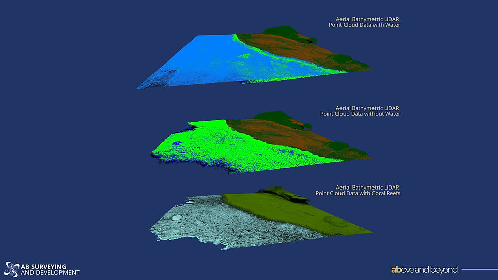
Aerial Bathymetric LiDAR
In shallow and relatively clear water, bathymetric surveys can also be performed from the air.
Bathymetric LiDAR uses a green laser capable of penetrating the water surface to measure the riverbed or seabed without requiring a survey vessel.
This technology is particularly effective for:
Coral reef mapping
Coastal engineering
River surveys
Environmental monitoring
Shallow coastal waters
Areas that are difficult or unsafe to access by boat
Because data can be collected from an aircraft, aerial bathymetric LiDAR can rapidly survey extensive areas while minimizing disruption to marine activities.
More Than Just Measuring Depth
Modern hydrographic surveys often incorporate additional sensors that provide information beyond water depth.
For example, Side Scan Sonar produces detailed acoustic images of the seabed, allowing surveyors to identify underwater structures, debris, pipelines, cables, and other objects that may not be visible from bathymetric data alone.
Sub-bottom Profilers look beneath the seabed, helping engineers understand sediment layers and underground geological conditions for marine construction and geotechnical investigations.
Marine Magnetometers detect variations in the Earth's magnetic field caused by buried ferrous objects such as pipelines, cables, shipwrecks, anchors, and unexploded ordnance.
Together, these technologies provide a far more complete understanding of the underwater environment than depth measurements alone.
Why Do These Offshore Surveying Services Matter?
Accurate underwater information plays a critical role in the planning, design, construction, and maintenance of marine and coastal infrastructure.
Hydrographic and bathymetric surveys support a wide range of projects, including:
Port and harbor development
Bridge construction
River rehabilitation
Dam and reservoir management
Dredging operations
Coastal protection projects
Flood mitigation studies
Marine environmental assessments
Offshore energy developments
Underwater utility and pipeline installations
Without accurate underwater data, engineers risk designing projects based on incomplete information, increasing the likelihood of costly redesigns, construction delays, and unforeseen site conditions.
Choosing the Right Survey
The choice between a hydrographic survey and a bathymetric survey is not always an either-or decision. In many cases, a bathymetric survey forms an essential component of a broader hydrographic investigation.
The most appropriate approach depends on the project's objectives. If the goal is simply to understand underwater depths and terrain, a bathymetric survey may be sufficient. However, if the project requires additional information such as navigation hazards, seabed characteristics, underwater structures, sediment conditions, or environmental data, a more comprehensive hydrographic survey may be necessary.
Understanding the difference allows project owners to request the right survey from the outset, helping ensure better planning, more reliable engineering designs, and more informed decision-making.
While the terms "hydrographic survey" and "bathymetric survey" are often used interchangeably, they serve different purposes.
Bathymetric surveying focuses on mapping the underwater terrain, while hydrographic surveying provides a broader understanding of the underwater environment and the conditions that influence marine and coastal projects.
Whether developing a port, managing a reservoir, designing a bridge, or studying a river system, both play an essential role in delivering the accurate data needed for successful engineering and infrastructure projects.
Like land surveying, understanding what lies beneath the surface is often the first step toward building with confidence.
Not sure which survey your project requires?


Comments