
LiDAR Surveying in
Mining
Accurate, timely survey data is critical to safe and profitable mining operations. AB Surveying and Development provides aerial, terrestrial, and mobile LiDAR surveying for mining companies across the Philippines — from exploration-stage terrain mapping to operational stockpile measurements, pit surveys, and slope monitoring that keeps projects compliant, efficient, and on schedule.
Challenges we solve
Common Challenges for LGUs & Urban Planners and How LiDAR Addresses Them
Challenges
Stockpile volume estimates are inaccurate and time-consuming using conventional methods
Open pit and quarry surveys are dangerous and slow to execute at scale
How LiDAR Helps
Traditional stockpile measurement using tapes, rods, or total stations is slow, physically hazardous on large piles, and prone to human error — producing volume estimates that can vary significantly between surveyors. For operations where stockpile inventory directly affects royalty payments, off-take contracts, and financial reporting, inaccurate measurements carry real commercial and compliance risk. Terrestrial LiDAR scanners capture the complete 3D surface of a stockpile in minutes, producing a dense point cloud from which precise volumes are calculated against a reference base surface. The result is a fast, safe, and fully auditable volume report that stands up to scrutiny from mine management, auditors, and regulators alike.
Sending survey crews into active pit environments or onto unstable highwalls exposes personnel to significant safety risk — and conventional total station surveys of large pits take days to complete, creating schedule pressure during active mining shifts. Aerial LiDAR captures the full pit geometry from above in a single flight, while terrestrial LiDAR scanners positioned at safe standoff distances capture wall faces and bench geometry with millimeter accuracy. Both approaches eliminate personnel exposure to hazardous zones while dramatically accelerating the survey cycle — allowing monthly or even weekly pit surveys without disrupting operations.
Slope stability and highwall deformation are difficult to monitor continuously
Highwall failures and waste dump instability are among the most serious risks in open pit mining — yet conventional monitoring methods are either point-based (prisms, inclinometers) or too infrequent to catch progressive deformation in its early stages. Repeat terrestrial LiDAR surveys produce full-surface deformation maps that reveal where walls are moving, at what rate, and across what extent — giving geotechnical engineers the spatial data they need to assess risk, adjust mining sequences, and implement remediation before a slope failure occurs. This approach is particularly valuable in Philippine mining operations subject to DENR-MGB slope monitoring requirements.
Mine permit and environmental compliance submissions require current, accurate survey data
Mining operations in the Philippines are subject to regular MGB and DENR reporting requirements — including quarterly production reports, annual EPEP updates, and mine rehabilitation fund assessments — all of which depend on accurate spatial data. Outdated or imprecise survey data creates compliance exposure and can delay permit renewals. AB Surveying provides fully documented, survey-grade LiDAR datasets with accuracy reports and metadata formatted for direct submission to Philippine regulatory agencies, reducing compliance burden and protecting permit status.
Exploration-stage terrain data is too coarse for mine planning and access road design
At exploration stage, mine planners routinely work with topographic data derived from SRTM or other coarse satellite sources — datasets that lack the resolution to support pit shell optimization, waste dump siting, tailings facility design, or access road engineering. Errors embedded in the base topography propagate through all downstream design decisions, leading to costly revisions during feasibility or construction. Aerial LiDAR surveys of mineral tenement areas deliver sub-meter terrain models that provide a reliable foundation for every subsequent planning and engineering activity — reducing downstream rework and improving the accuracy of project cost estimates from the outset.
LiDAR Surveying Applications in Mining
Across every stage of the mine lifecycle — from exploration to rehabilitation — LiDAR data improves safety, efficiency, and regulatory compliance.
Stockpile Volume Measurement
Terrestrial and aerial LiDAR for accurate, auditable stockpile volume calculations — supporting inventory reporting, royalty reconciliation, off-take documentation, and financial audits.
Slope & Highwall Monitoring
Repeat LiDAR surveys to detect surface deformation on pit walls and waste dumps — providing early warning data for geotechnical risk assessment and DENR-MGB slope monitoring compliance.
Exploration Terrain Mapping
High-accuracy topographic surveys of mineral tenement areas providing the spatial foundation for resource modeling, pit shell design, waste dump siting, and tailings facility planning.
Tailings Storage Facility (TSF) Survey
Volumetric and structural surveys of tailings storage facilities monitoring embankment geometry, freeboard, and deposition patterns for safety compliance and capacity planning.
Open Pit & Quarry As-Built Survey
Full pit geometry capture — walls, benches, and floors — for cut volume verification, design compliance checks, and as-built documentation. Executed without exposing crews to hazardous pit environments.
Mine Permit & EPEP Spatial Data Support
Survey-grade terrain and volumetric datasets formatted for MPSA compliance, DENR-MGB quarterly and annual reporting, and Environmental Protection and Enhancement Program submissions.
Access Road & Infrastructure Design
LiDAR terrain models for haul road alignment, gradient design, drainage planning, and infrastructure corridor routing within and around mine lease areas.
Mine Rehabilitation & Closure Monitoring
Repeat LiDAR surveys to document progressive rehabilitation — tracking revegetation, re-contouring progress, and drainage restoration against mine closure plan requirements.

What Our Clients Get:
3D Colorised Point Cloud Data
A point cloud data containing millions of precisely located points overlaid with orthophoto RGB creating a realistic 3D city model.
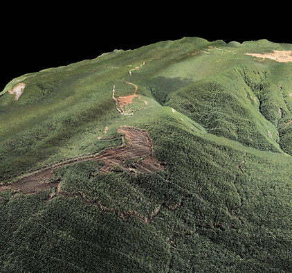
PROJECT SPOTLIGHT
AB Surveying and Development conducted an Aerial Topographic LiDAR survey covering 2,571 hectares for a mining company in Dinapigue, Isabela. Using the RIEGL VUX-240 — a survey-grade airborne LiDAR system — the survey captured high-accuracy terrain data across the mineral tenement area, providing the client with a reliable topographic foundation for mine planning, compliance, and operational decision-making.
AREA SURVEYED
2,571 ha.
YEAR COMPLETED
2018
Our Services
.jpg)


_edited.jpg)

We were amazed at how fast AB Surveying and Development's LiDAR mapping was as compared to conventional surveying methods.
With approximately 1,000 hectares of land area, the Kiangan, Ifugao project site was accurately generated as a topographic map and was very useful for the planning and design of the proposed Hucab Mini Hydro Electric Plant. The team was very accommodating and helpful in every step of the way, and they almost eliminated the need for physical site inspection because of their attention to detail!
Highly recommended to all our industry peers!
Patrick Talibon, Business Line Manager, Pacific Tech Solutions, Inc.