LiDAR vs. Traditional Surveying: What's the Real Difference in Cost and Output?
- denisebotor
- Jun 3
- 7 min read
Whether you’re planning a renewable energy project, developing a new township, designing critical infrastructure, updating a Comprehensive Land Use Plan (CLUP), conducting flood studies, or preparing a detailed engineering design, one thing remains constant: the quality of your project depends on the quality of your survey data.
One of the first requirements is accurate topographic data. After all, every engineering design, flood simulation, infrastructure project, or land-use decision is only as good as the data it is built upon.
Traditionally, topographic surveys have been conducted using surveyors on the ground equipped with Total Stations and GNSS receivers. Today, however, many LGUs and developers are increasingly turning to LiDAR technology to collect terrain information over large areas.
This often raises the question:
Is LiDAR simply a more expensive way to conduct a survey, or does it provide significantly greater value?
The answer lies not only in cost, but also in how the data is collected, the outputs produced, and the scale of the project being undertaken.
Understanding Traditional Topographic Surveying

For decades, conventional topographic surveying has been the standard method for collecting terrain information.This process typically involves the use of either a Total Station or an RTK GNSS (Real-Time Kinematic Global Navigation Satellite System) receiver.
A Total Station measures distances and angles between the instrument and a prism positioned by a surveyor on the ground. By combining these measurements, the coordinates and elevations of individual points can be determined with high accuracy.
RTK surveying, on the other hand, uses satellite signals enhanced by correction data from a base station to determine precise coordinates in real time. This allows surveyors to collect data more efficiently without relying on line-of-sight measurements.
While both methods are highly accurate, they share one common limitation: surveyors must physically access the locations they intend to measure.
A survey team may establish several control points throughout a project area before moving from point to point collecting terrain information. Depending on the size of the project, terrain conditions, vegetation density, and required level of detail, surveyors may need to reposition equipment dozens or even hundreds of times throughout the survey.
For open and accessible areas, this process can be straightforward. However, conditions become more challenging when projects involve steep mountains, dense forests, rivers, marshlands, agricultural areas, or remote locations. In these situations, productivity is often determined not by the equipment itself, but by how quickly surveyors can physically move through the site. Simply put, if a surveyor cannot safely and efficiently reach a location, obtaining measurements becomes more difficult, time-consuming, and costly.
This is one of the reasons why conventional surveying remains highly effective for smaller project areas but becomes increasingly resource-intensive as project size grows.
How LiDAR Surveying Works
LiDAR, or Light Detection and Ranging, takes a fundamentally different approach.
Instead of measuring terrain one point at a time, LiDAR systems collect millions of measurements every second from the air.

In an aerial LiDAR survey, a laser scanner is mounted on an aircraft. As the aircraft flies over the project area, the sensor continuously emits laser pulses toward the ground. Each pulse travels from the aircraft, reflects off a surface, and returns to the sensor. By measuring the time it takes for the laser to return and combining this information with precise GPS and inertial measurement unit (IMU), the system calculates the exact location of the reflected point. A useful way to visualize this process is to think of each laser pulse as a survey measurement.
A conventional survey team may collect several thousand points over the course of a day. An aerial LiDAR system, meanwhile, can emit hundreds of millions of laser pulses every second, collecting billions of measurements during a single survey mission.
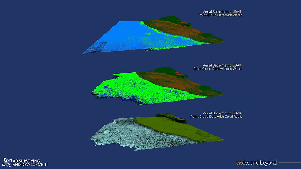
The result is a highly detailed three-dimensional dataset known as a point cloud. Each point contains precise X, Y, and Z coordinates, creating a digital representation of the terrain and everything on it. Unlike conventional surveys that sample specific locations, LiDAR captures continuous information across the entire survey area.
Many modern LiDAR systems are also integrated with high-resolution cameras. These cameras capture aerial imagery simultaneously with the laser data, enabling the creation of orthophotos and colorized point clouds.
The result is not only accurate terrain information, but also a realistic representation of the project area that can be easily understood by planners, engineers, investors, and decision-makers.

This density of information and a realistic representation of the project site are some of the primary reasons why LiDAR has become the preferred solution for large-scale mapping, flood studies, renewable energy projects, and digital twin initiatives.
From Point Clouds to Engineering-Ready Data
The value of LiDAR extends beyond simply collecting more measurements. After processing, the point cloud can be classified into different categories such as ground, vegetation, buildings, roads, powerlines, and other infrastructure.

From this dataset, surveyors can generate several products including:
Digital Surface Models (DSM)
Digital Terrain Models (DTM)
Contour Maps
Orthophotos
3D Point Clouds
Cross Sections and Profiles
Digital Twins
A Digital Surface Model represents everything visible on the earth's surface, including trees, buildings, and structures.
A Digital Terrain Model removes these features to reveal the bare-earth terrain beneath.
For flood mapping, flood simulations, drainage master planning, infrastructure design, and renewable energy site selection, the Digital Terrain Model is often one of the most valuable outputs.
The Difference in Output: Why Visualization Matters
One of the most overlooked differences between conventional surveying and LiDAR surveying is how the final outputs are consumed.
Traditional topographic surveys typically produce contour maps, CAD drawings, spot elevations, and coordinate lists. These outputs are invaluable to engineers and surveyors but may be difficult for non-technical stakeholders to interpret.
For example, a contour map can effectively communicate terrain information to an engineer, but may not be immediately understandable to an investor, government official, or community stakeholder.

LiDAR datasets, on the other hand, provide a much richer and more visual representation of the project area. Using a LiDAR point cloud, stakeholders can virtually inspect a site without physically visiting it. Terrain can be viewed in three dimensions, infrastructure can be examined from multiple perspectives, and fly-through visualizations can be generated to communicate project conditions more effectively.

For LGUs conducting planning workshops, public consultations, flood mitigation studies, or investment presentations, this ability to visualize data often leads to better understanding and more informed decision-making.
Simply put, both methods can provide accurate terrain information, but LiDAR often provides significantly more context.
Is LiDAR Suitable for Detailed Engineering?
A common misconception is that LiDAR is only useful for planning-level studies and not detailed engineering work. In reality, modern aerial LiDAR systems can produce datasets suitable for engineering design, provided that the survey is flown to the correct specifications.
The key consideration is point density.
Point density refers to the number of LiDAR measurements collected within a square meter. Higher point densities allow surveyors and engineers to capture finer levels of detail. Depending on the sensor, flight altitude, and project requirements, LiDAR surveys can be designed to achieve point densities suitable for:
Detailed Design and Engineering
Flood Simulation Studies
Wind Farm Development
Transmission Line Design
Road and Highway Design
Digital Twin Development
Infrastructure Planning
The suitability of LiDAR for engineering applications depends less on the technology itself and more on whether the survey has been designed to meet the required accuracy and density specifications.
Not All LiDAR Systems Are the Same
Another important consideration is that not all LiDAR providers use the same equipment.
Just as there are differences between surveying instruments, there are significant differences between LiDAR systems.
Some LiDAR sensors are designed primarily for small-area drone operations. These systems can be highly effective for localized projects but may become inefficient for regional-scale mapping.
Other systems are designed for large-area aerial acquisition using manned aircraft and can efficiently survey hundreds or even thousands of hectares in a single mission.
Differences may also exist in:
Sensor accuracy
Point density capabilities
Flight efficiency
Ground penetration performance
Processing methodologies
Deliverable specifications
For this reason, project owners should communicate their objectives clearly to their survey provider. The size of the project area, required deliverables, engineering requirements, vegetation conditions, and intended use of the data all influence the type of LiDAR system that should be deployed.
Selecting a LiDAR provider should not be based solely on price. It should also consider whether the technology being used is appropriate for the project's scale and objectives. You may also read our previous blog "5 Questions/Key considerations when selecting a surveyor" to know more.
The Cost Question: Which Method Is More Economical?
The most common concern regarding LiDAR surveying is cost.
At first glance, aerial LiDAR surveys may appear more expensive than conventional topographic surveys. However, the comparison becomes more meaningful when project size is taken into account.
For smaller projects, particularly those under approximately 50 hectares, conventional surveying or survey-grade drone LiDAR often remains the most economical option. Mobilizing an aircraft for a small project may not provide sufficient efficiency gains to offset operational costs. However, as project size increases, however, the economics begin to change.
A manned aerial LiDAR system can collect data over hundreds or thousands of hectares in a fraction of the time required by conventional survey methods.
This significantly reduces:
Field manpower requirements
Mobilization costs
Travel expenses
Project duration
Safety risks associated with difficult terrain


Comments