![[ABSD] White Logo.png](https://static.wixstatic.com/media/c6ec9d_74fae8190bdc4b4bbae4d07cc36b8aff~mv2.png/v1/fill/w_193,h_48,al_c,q_85,usm_0.66_1.00_0.01,enc_avif,quality_auto/%5BABSD%5D%20White%20Logo.png)
Understanding Hydrographic Survey Deliverables: What You'll Receive and Why They Matter
After deciding which hydrographic survey technology is best suited for your project, one of the next questions we commonly receive at AB Surveying is:
"What exactly will we receive after the survey is completed?"
It's a great question and one that often surprises people.
Many assume a hydrographic survey simply produces a map showing water depths. While bathymetric maps are certainly one of the final outputs, modern hydrographic surveys can generate a wide range of deliverables depending on the survey method used and the project's objectives.
This is an important distinction because not every survey technology produces the same outputs. A Single Beam Echo Sounder (SBES), for example, collects data differently from a Multibeam Echo Sounder (MBES) or Aerial Bathymetric LiDAR. As a result, the deliverables and the level of detail they provide also differ.
Understanding what each survey method typically produces can help project owners select the right technology and ensure they receive the information needed for planning, design, construction, environmental management, or long-term asset maintenance.
Deliverables from a Single Beam Echo Sounder (SBES) Survey
Single Beam Echo Sounders measure one depth point directly beneath the survey vessel with every acoustic pulse. Because measurements are collected along predetermined survey lines, the deliverables focus on accurately representing the underwater terrain through sampled profiles and terrain models.
Typical deliverables include:
Bathymetric Survey Plan
Spot Depths
Cross Sections
Longitudinal Profiles
Digital Terrain Model (DTM)
Bathymetric Contours
CAD Drawings
Survey Report
Cross Sections and Longitudinal Profiles
One of the most common deliverables from an SBES survey is a series of river or channel cross sections. These profiles illustrate how the riverbed or canal changes across and along the waterway, making them particularly valuable for bridge design, flood studies, river rehabilitation, and irrigation projects.
Why it matters
Cross sections allow engineers to evaluate channel capacity, identify sediment build-up, monitor erosion, and assess changes in the riverbed over time.
Digital Terrain Model (DTM)
Although SBES collects measurements along survey lines rather than complete seabed coverage, the collected depths can still be processed into a Digital Terrain Model.
The DTM provides a continuous representation of the underwater terrain and forms the basis for engineering analysis.
Why it matters
Engineers use DTMs to support reservoir studies, and infrastructure planning.
Bathymetric Contours
Bathymetric contours connect locations with equal water depths, allowing underwater terrain to be interpreted in a familiar map format.
Why it matters
Contour maps remain one of the most widely used deliverables because they provide a simple yet effective way to communicate underwater topography.
CAD Drawings and Survey Reports
Survey data is commonly delivered as CAD drawings showing contours, spot depths, cross sections, and survey control information, together with a technical report documenting the survey methodology, equipment used, and survey accuracy.
Best suited for:
Rivers
Irrigation canals
Inland waterways
Reservoirs
Preliminary engineering investigations
Deliverables from a Multibeam Echo Sounder (MBES) Survey

Unlike SBES, a Multibeam Echo Sounder measures hundreds of depth points simultaneously across a wide swath beneath the survey vessel. Because the seabed is measured almost continuously, MBES surveys generate significantly more detailed datasets.
Typical deliverables include:
Bathymetric Point Cloud
High-Resolution Digital Terrain Model (DTM)
Bathymetric Contours
TIN Surface
Hillshade and Seabed Relief Maps
Cross Sections
Volume Computations
CAD Drawings
Survey Report
Bathymetric Point Cloud
Perhaps the most valuable deliverable produced by an MBES survey is the bathymetric point cloud.
Much like terrestrial or aerial LiDAR surveys produce millions of points representing land surfaces, MBES surveys generate dense three-dimensional points representing the underwater terrain.
Each point contains precise horizontal and vertical coordinates, allowing engineers to inspect the seabed in remarkable detail.
Why it matters
Point clouds preserve the original survey information and allow engineers to revisit the dataset for additional measurements, visualization, and future analysis without returning to the field.
High-Resolution Terrain Models
Because Multibeam surveys provide nearly complete seabed coverage, they produce highly detailed Digital Terrain Models capable of representing subtle underwater features that may not be captured using more widely spaced survey lines.
Why it matters
These terrain models support dredging design, marine construction, navigation studies, and offshore engineering projects where complete seabed coverage is essential.
Volume Computations
One of the most common deliverables requested from MBES surveys is dredging volume computation. By comparing the surveyed seabed against a design elevation—or by comparing two surveys conducted at different times, engineers can accurately determine excavation or sedimentation volumes.
Why it matters
Accurate volume calculations support budgeting, contractor payments, dredging progress monitoring, and long-term maintenance planning.
Best suited for:
Ports and harbors
Navigation channels
Offshore infrastructure
Dredging projects
Marine engineering
Deliverables from an Aerial Bathymetric LiDAR Survey
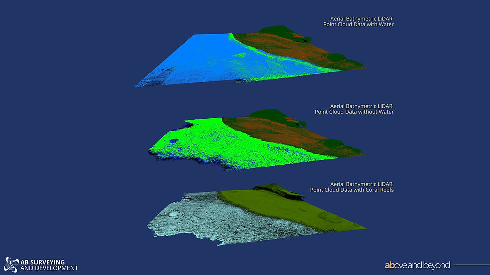
Unlike vessel-based survey methods, Aerial Bathymetric LiDAR uses a green laser mounted on an aircraft to measure the seabed in clear, shallow waters. It is particularly effective in areas where operating a survey vessel may be difficult, inefficient, or environmentally sensitive, such as coral reefs, river mouths, shallow coastlines, and protected marine areas. Rather than relying on acoustic sound waves, the green laser penetrates the water column and measures the seabed below, allowing large shallow-water areas to be surveyed efficiently from the air.
Typical deliverables include:
Bathymetric Point Cloud
Digital Terrain Model (DTM)
Bathymetric Contours
Shoreline Mapping
Orthophotos
Cross Sections
CAD Drawings
Survey Report
Bathymetric Point Cloud
One of the primary deliverables of an Aerial Bathymetric LiDAR survey is a dense bathymetric point cloud representing the underwater terrain in shallow, clear waters.
This three-dimensional dataset enables engineers and planners to visualize the seabed, perform detailed measurements, and generate additional engineering deliverables without returning to the field.
Why it matters
The point cloud provides a permanent digital record of the surveyed environment and forms the foundation for terrain models, contour maps, cross sections, and other engineering analyses.
Digital Terrain Model (DTM) and Bathymetric Contours
The bathymetric point cloud is processed into a Digital Terrain Model (DTM), which represents the underwater terrain as a continuous surface. Bathymetric contours are then generated from this terrain model to provide an easy-to-read representation of water depths.
Why they matter
Together, these deliverables help engineers understand underwater topography for coastal engineering, river studies, environmental assessments, and shoreline management.
Orthophotos and Shoreline Mapping
Because the survey is conducted from an aircraft equipped with a high-resolution camera, Aerial Bathymetric LiDAR projects also produce orthophotos of the project area.
Combined with shoreline mapping, these deliverables provide valuable visual context alongside the bathymetric data, allowing project teams to clearly understand the relationship between the coastline and adjacent shallow-water environments.
Why they matter
Orthophotos and shoreline mapping support coastal planning, environmental monitoring, habitat assessments, and shoreline change analysis while complementing the bathymetric information collected beneath the water.
Best suited for:
Shallow coastal waters
Coral reef mapping
Protected marine areas
River mouths and estuaries
Shoreline monitoring
Environmental assessments
Coastal engineering projects
Comparing Hydrographic Survey Deliverable
The deliverables produced by a hydrographic survey depend on the survey technology used. While several outputs are common across multiple methods, the level of detail and primary deliverables vary considerably.
Deliverable | Single Beam Echo Sounder (SBES) | Multibeam Echo Sounder (MBES) | Aerial Bathymetric LiDAR |
Primary Data | Individual depth measurements collected along survey lines | Dense bathymetric point cloud with near-complete seabed coverage | Dense bathymetric point cloud for clear, shallow waters |
Digital Terrain Model (DTM) | ✓ Generated from surveyed depth points | ✓ High-resolution terrain model | ✓ Terrain model for shallow-water environments |
Bathymetric Contours | ✓ | ✓ | ✓ |
Cross Sections & Profiles | ✓ | ✓ | ✓ |
Volume Computations | ✓ Suitable for many engineering applications* | ✓ Highly detailed and commonly used for dredging | ✓ Applicable for selected shallow-water and coastal projects |
CAD Drawings | ✓ | ✓ | ✓ |
Survey Report | ✓ | ✓ | ✓ |
Bathymetric Point Cloud | ✗ | ✓ | ✓ |
Orthophotos | ✗ | ✗ | ✓ Included as part of the aerial survey |
Typical Applications | Rivers, canals, reservoirs, inland waterways | Ports, harbors, navigation channels, offshore infrastructure | Coral reefs, shallow coastal waters, protected marine areas, river mouths |


Comments